
Finding the Location Is the Easy Part
Milky Way Planner tells you when and where to shoot. It doesn't tell you if you can get there. Here's how I use Trails Offroad to solve the second half of the planning problem.
I spend a lot of time thinking about location planning. Most of that thinking runs through milkywayplanner.com where I'm checking galactic core timing windows, moon phase, and visibility ratings for a spot months out before I commit to the drive. That part of the process I've got pretty well dialed in.
But there was a second problem I kept solving separately: can I actually get there? Knowing that Marlboro Point in Canyonlands has a great view of Shafer Canyon doesn't tell you what the road out there actually involves. Whether the road is actually drivable is a different question entirely. For a long time I was doing it the slow way, piecing together forum posts and trip reports or just showing up and finding out. A few years ago, I started using Trails Offroad, and it changed that half of the planning process.
The Two Parts of Astrophotography Location Planning
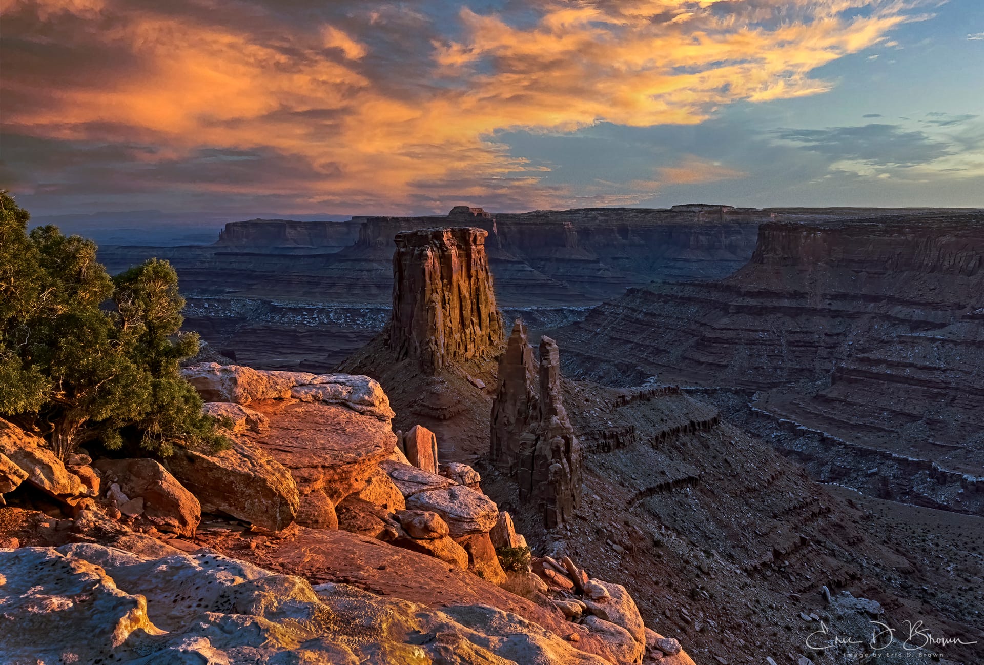
Marlboro Point sits near Dead Horse Point State Park, on the edge of Canyonlands' Island in the Sky district, looking out over Shafer Canyon: vertical canyon walls, sweeping desert, the kind of foreground that makes a Milky Way shot work. If you plan your timing right, the galactic core rises over that canyon in late spring and early summer. It's a genuinely good spot.
You're not getting there in a sedan or most crossovers. The road out has vertical rock steps and blind ledges up to 6-8 inches tall. You need real clearance and four-wheel drive. There are spots where you commit before you can see the landing.
I drive a Jeep Wrangler Rubicon 392, lifted on 37s, so getting to Marlboro Point doesn't worry me. But I still check before I go, because knowing the rating, the specific challenges, and what the access looks like before I'm 10 miles down a dirt road with no cell service is just good planning.
What the Trails Offroad Guide Actually Says
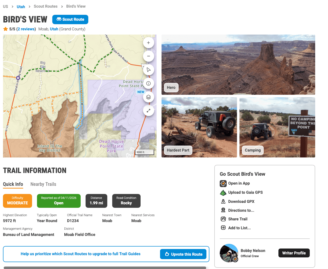
Every trail has a difficulty rating and a plain-English description of what to expect. For the Bird's View route out toward Marlboro Point, the guide rates it Moderate, and explains what that means in practice:
"With a Bird's Eye view of the Bird's Eye and Crow's Head Spires, D1234 is an easy way to get to a fantastic overlook of Shafer Canyon and beyond. The trail is perfect for beginners in capable stock 4x4s looking to avoid the more difficult rock crawling trails leading to overlooks. There are vertical rock steps and blind ledges 6-8" tall to navigate."
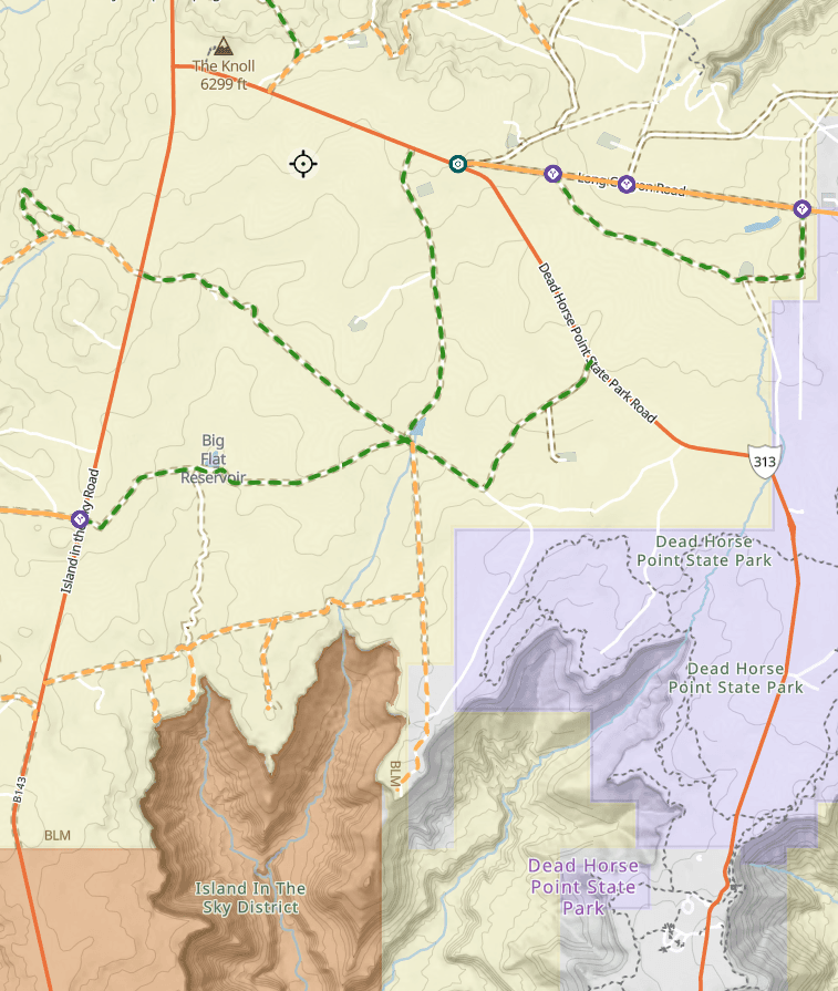
"Beginners in capable stock 4x4s" means a bone-stock Wrangler or 4Runner gets through fine. The ledges are real, but the trail doesn't require anything exotic. The overview map also shows how the trail network connects through the area, so you know your route before you're squinting at a GPS screen in the dark.
Running Both Tools for Off-Road Astrophotography Locations
I run both tools in parallel now. I'll check milkywayplanner.com to figure out when the galactic core timing lines up for a specific location. Then I'll pull up Trails Offroad to check how I'm getting there, what the difficulty looks like, and whether there's camping nearby if I want to stay overnight and shoot the pre-dawn window too.
Trails Offroad lets you make an informed call before you go, even if you're not sure your vehicle can handle it. If the rating's too high for what you're driving, you find out at your desk instead of at a trailhead. You pick a different access point. Maybe you drive to a certain spot and hike the rest of the way. Either way, you're not turning around 45 minutes in because you ran out of clearance.
Free vs. Paid, and Why I Mention It
The site has both free Scout Routes and paid Full Trail Guides, depending on the area and trail complexity. For most of the off-road photography locations I scout, there's enough free information to make a go/no-go call. The paid guides go deeper: GPS tracks, additional photos, user reports. For destinations I'm driving a long way to reach, I find them worth having. I use the paid version and think it's worth the annual fee.
I've used Trails Offroad enough over the past few years that I became an ambassador for them. I mention that because it's worth knowing, but the recommendation isn't new. I was using it before that, for the same reason I'm writing about it now: it answers the question that the timing tools can't.
Knowing the right place and the right night is most of it. Getting there still takes its own research.
Plan your astrophotography timing windows at milkywayplanner.com. For trail access and off-road conditions, Trails Offroad is what I use.


